Car-centric cities and urban redesign are now inseparable topics. For much of the 20th century, cities across North America, Europe, the Middle East, and parts of Asia were systematically rebuilt around the automobile. Highways cut through neighborhoods, parking lots replaced street-level retail, and pedestrian space was reduced to narrow sidewalks squeezed between traffic lanes. The results are now measured in pollution data, public health statistics, and economic decline along car-dominated corridors. A growing number of cities are spending billions to reverse decisions that previous generations spent billions to implement.
How Cities Became Car-Centric in the First Place

The Post-War Period and the Dominance of the Highway

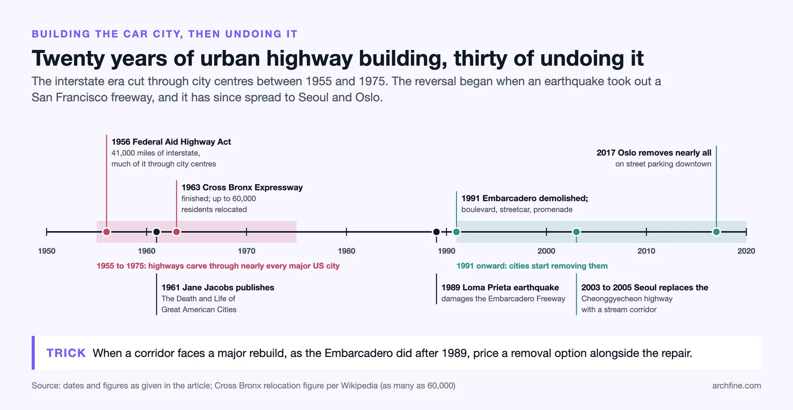
The postwar period, particularly in the United States, saw the most intensive period of car-oriented city building in history. The Federal-Aid Highway Act of 1956 authorized the construction of 41,000 miles of interstate highway, much of it routed directly through urban centers. Cities that had developed around streetcar networks, walking distances, and mixed-use neighborhoods were carved apart by multi-lane expressways designed to move suburban commuters through the city as quickly as possible.
The consequences were immediate and severe. Neighborhoods in the path of the highways were demolished, displacing hundreds of thousands of residents, disproportionately from low-income and minority communities. Streets that had been commercial and social centers became service roads for highway on-ramps. The Strong Towns organization has documented how this pattern of highway-driven destruction repeated itself in nearly every major American city between 1955 and 1975.
Robert Moses and the Ideology of the Car City

No single figure embodied the car-centric city design failure more completely than Robert Moses, the unelected power broker who shaped New York City’s infrastructure from the 1930s through the 1960s. Moses built highways, bridges, and parkways that prioritized vehicular speed and suburban access over neighborhood integrity. His Cross-Bronx Expressway, completed in 1963, displaced as many as 60,000 residents and is widely credited with accelerating the decline of the South Bronx.
Moses operated on an ideology that equated car access with progress and modernity. Pedestrians, cyclists, and public transit users were treated as obstacles to the smooth flow of traffic rather than as the primary users of the city. This ideology was not unique to Moses. It was shared by city planners, highway engineers, and federal policy makers across the country. The car city was not an accident. It was a policy choice.
📌 Did You Know?
In the 1950s, a plan was proposed to run an elevated highway through lower Manhattan, destroying much of what is now SoHo and the West Village. The plan was defeated by a coalition of residents led by the activist Jane Jacobs, whose opposition to Moses-style highway planning became one of the most influential citizen campaigns in urban design history. Her book, The Death and Life of Great American Cities (1961), remains required reading in urban planning programs worldwide.
What Car-Centric Design Actually Produced
The Death of Street Life
Streets designed for maximum vehicle throughput are hostile to every other use. Wider roads mean longer pedestrian crossing distances, higher vehicle speeds, and greater risk of injury or death for anyone on foot. The Institute for Transportation and Development Policy reports that pedestrian fatalities are directly correlated with road width and vehicle speed: every additional lane of traffic increases pedestrian risk measurably.
Beyond safety, car-dominated streets eliminate the conditions for street life. Outdoor dining, window shopping, casual conversation, and the simple act of watching other people all depend on a street environment where walking is comfortable, safe, and pleasant. When the street is a traffic corridor, these activities disappear. Retailers on car-dominated arterials report lower foot traffic and higher vacancy rates than comparable retailers on pedestrian-friendly streets.
Environmental and Health Costs
Car-dependent city design produces measurable environmental and health outcomes. Vehicle emissions are the largest source of nitrogen dioxide and particulate matter in most urban areas. Impervious road and parking surfaces increase stormwater runoff and urban heat island effects. The land area dedicated to roads and parking in many American cities exceeds 30% of the total urban footprint, land that produces no tax revenue and cannot support housing, commerce, or green space.
The health costs are equally direct. Residents of car-dependent neighborhoods drive more, walk less, and have higher rates of obesity, diabetes, cardiovascular disease, and respiratory illness than residents of walkable neighborhoods. The UN-Habitat has identified car dependency as a contributing factor to the global rise in non-communicable diseases associated with sedentary lifestyles.
⚠️ Common Mistake to Avoid
Assuming that removing car infrastructure will increase traffic congestion elsewhere. Research on induced demand shows that when road capacity is added, traffic increases to fill it. The reverse is also true: when road capacity is removed, traffic decreases. This phenomenon, called “disappearing traffic,” has been documented in every major highway removal project. People adjust their behavior when the infrastructure changes.
Cities That Have Removed or Reduced Car Infrastructure
Seoul’s Cheonggyecheon Stream Highway Removal
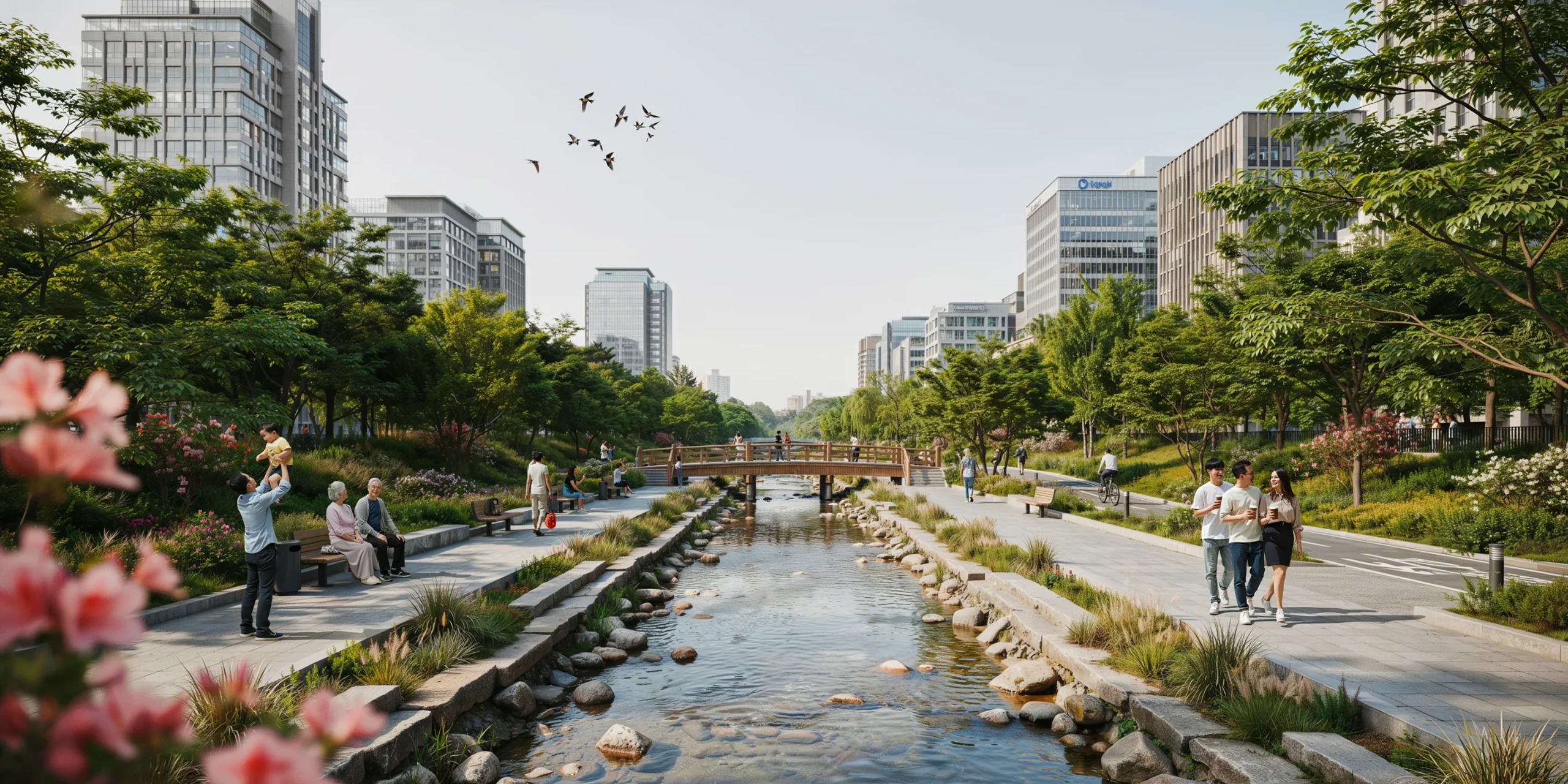

In 2003, Seoul began demolishing the Cheonggyecheon Elevated Highway, a 5.6-kilometer elevated expressway that had been built over the Cheonggyecheon Stream in the 1960s. The highway was replaced with a restored urban stream corridor, flanked by pedestrian paths, parks, and public spaces. The project was completed in 2005 at a cost of about 386 billion won (roughly $281 million).
The results exceeded projections. Traffic on surrounding roads did not increase to the degree that opponents had predicted, confirming the disappearing traffic effect. Property values along the restored stream corridor increased by 30 to 50%. Biodiversity in the stream recovered rapidly, with fish species rising from 4 to 25, bird species from 6 to 36 and insect species from 15 to 192 between 2003 and 2008. The area became one of the most visited public spaces in Seoul, attracting an estimated 64,000 visitors per day. The project demonstrated that removing urban highways and replacing them with public space could produce economic, environmental, and social benefits simultaneously.
🏗️ Real-World Example
Before the Cheonggyecheon restoration, the elevated highway carried approximately 168,000 vehicles per day. After its removal, a large share of those trips simply disappeared rather than shifting to nearby roads: drivers either switched to public transit, combined trips, or chose not to make the journey. This confirmed the theory of disappearing traffic and became one of the most cited case studies in the urban highway removal movement.
San Francisco’s Embarcadero Freeway (Demolished 1991)
The Embarcadero Freeway was a double-deck elevated highway that separated San Francisco’s downtown from its waterfront. Damaged in the 1989 Loma Prieta earthquake, it was demolished in 1991 despite significant opposition from commuters and some business owners. The freeway was replaced with a surface boulevard, a streetcar line, and a waterfront promenade.
The transformation was dramatic. The Embarcadero waterfront became one of the most desirable addresses in San Francisco. The Ferry Building was restored as a public market. Property values along the former freeway corridor increased significantly. The project became a template for highway removal projects in other American cities, demonstrating that the economic fears of freeway removal were consistently overstated.
Oslo’s Near-Car-Free City Centre
Oslo has pursued one of the most aggressive anti-car city design strategies in Europe. Beginning in 2017, the city removed nearly all on-street parking from its center, replacing parking spaces with bike lanes, wider sidewalks, planting, and public seating. The city also implemented congestion pricing and invested heavily in public transit and cycling infrastructure.
The results have been consistent with other pedestrianization urban examples. Retail sales in the car-free zone did not decline as opponents predicted. Cycling increased by over 60%. Air quality improved measurably. Pedestrian counts in the city center increased, and businesses reported that the improved street environment attracted more customers, not fewer. Oslo’s approach shows that even in a cold northern climate, reducing car dominance in city centers produces positive outcomes.
What Replacing Car Space Actually Looks Like
Parklets, Plazas, and Repurposed Lanes


The physical transformation of car space into people space takes many forms. Parklets convert one or two parking spaces into small public seating areas. Parking lane removal creates space for protected bike lanes. Road diets reduce a four-lane road to two lanes with a center turn lane and bike lanes, slowing traffic and improving safety without reducing capacity for most traffic volumes. Intersection daylighting removes parking spaces at corners to improve sightlines and pedestrian visibility.
These interventions are inexpensive relative to their impact. A parklet costs $5,000 to $50,000 depending on materials and permanence. A protected bike lane can be implemented with bollards and paint for a fraction of the cost of a new road. Street redesign for people does not require demolishing infrastructure. It requires reallocating the space that already exists.
What Happens to Property Values When Streets Are Pedestrianized
Property value data from pedestrianized streets across Europe, North America, and Asia consistently shows increases following car removal. Studies from Copenhagen, Melbourne, New York, and Barcelona all report commercial property value increases of 10 to 40% on pedestrianized streets within five years of implementation. Residential property values show similar patterns.
The mechanism is straightforward: pedestrian-friendly streets attract more foot traffic, which supports more retail, which increases demand for commercial and residential space. The post-car urban planning model produces an economic feedback loop that car-dominated streets cannot match because car traffic does not stop, browse, or spend money at street level in the same way that pedestrian traffic does.
💡 Pro Tip
If you are advocating for pedestrianization in a project or neighborhood, lead with economic data rather than environmental arguments. Property value increases, retail sales data, and foot traffic counts are more persuasive to decision-makers and business owners than air quality improvements or carbon reduction figures. The economic case for removing car infrastructure is strong and well documented.
The Resistance These Changes Always Face
The Parking Lobby and Business Owner Concerns
Every pedestrianization and car-removal project faces opposition, and the concerns are predictable. Business owners fear that removing parking will reduce customer access. Commuters fear that removing road capacity will increase travel times. Property owners fear that construction disruption will harm values. Delivery operators fear that vehicle restrictions will impede logistics.
The evidence from completed projects consistently shows that these fears are overstated. Foot traffic increases compensate for lost parking. Induced demand means that traffic often decreases rather than increasing when capacity is removed. Property values rise. Delivery logistics can be managed through time-restricted access. But the fears are real and sincerely held, and overcoming them requires data, pilot programs, and the willingness to demonstrate results before demanding permanent commitment.
Equity Questions in Car-Free Planning
The equity dimension of cities removing car infrastructure deserves serious attention. Not everyone can cycle, walk, or use public transit. People with mobility disabilities, parents with young children, shift workers with irregular schedules, and residents of poorly served transit areas may genuinely depend on car access. Removing car infrastructure without providing viable alternatives for these groups risks creating a two-tier city: pleasant and walkable for the able-bodied and well-located, and less accessible for everyone else.
The most equitable approaches combine car restriction with investment in public transit, paratransit, accessible cycling infrastructure, and delivery logistics. Oslo’s strategy included significant expansion of public transit service alongside its car-reduction measures. Barcelona’s Superblocks program preserves vehicle access for residents, deliveries, and emergency services while restricting through-traffic. The goal is not to eliminate cars entirely but to reclaim the disproportionate share of public space that has been allocated to them for decades while ensuring that mobility remains accessible to all residents.
✅ Key Takeaways
- Car-centric city design was a deliberate policy choice, driven by postwar highway programs and the ideology that equated car access with progress.
- The documented outcomes include reduced street life, higher pedestrian fatality rates, increased air pollution, and worse public health indicators in car-dependent areas.
- Seoul’s Cheonggyecheon restoration, San Francisco’s Embarcadero demolition, and Oslo’s car-free center all produced economic, environmental, and social benefits that exceeded projections.
- Removing car infrastructure does not typically increase congestion elsewhere. The disappearing traffic effect has been confirmed in every major highway removal project.
- Equity must be addressed alongside car reduction: public transit, accessible cycling, and paratransit must be expanded to ensure mobility for all residents.